Final Update on GSoC 2026 project
Hi everyone,
I am Pranav Angrish, and this summer I worked with 52°North as part of Google Summer of Code 2026 on the project MCP for OGC APIs: Developing Model Context Protocols for the Suite of OGC APIs. In my first blog post, I introduced the main idea behind the project: making OGC APIs easier to use through the Model Context Protocol (MCP). In my midterm update, I described the standardized Python MCP server, the discovery-first workflow, the planner for process execution, and proxy memory for large responses.
During the second half of the program, I focused on turning those backend capabilities into a complete user-facing workflow. I built a React-based conversational interface, connected it to Gemini through a Node.js gateway, added safe human confirmation for process execution, prepared process outputs as reusable artifacts, and added visual presentations for supported geospatial results. The result is no longer only an MCP server that exposes OGC API operations. It is a prototype of an end-to-end geospatial assistant in which a user can ask a question in natural language, the model can discover the right OGC API capability, the server can validate and execute the operation safely, and the interface can show the result as text, a map, a table, a chart, a metric, an image, or a download.
From an MCP Server to an End-to-End System
At midterm, the central implementation was the Python reference server. It provides stable ogc_* MCP tools for OGC API – Common, Features, Records, Processes, and Jobs. The important design principle was that the language model should not guess endpoints, process IDs, or input names. Instead, it should discover the registered server, inspect the available capabilities, and use the exact metadata returned by the OGC API.
In the second half of the project, I added the missing user-facing layer. The system is now made of four cooperating parts:
- React UI: the browser application where the user writes requests, reviews a plan, and sees results.
- Node.js gateway: the application server that maintains the conversation, connects to Gemini, calls MCP tools, prepares safe output events, and streams updates back to the browser.
- Gemini: the reasoning component that decides which available MCP tool is relevant and writes the final natural-language explanation.
- Python MCP server: the authoritative OGC proxy that talks to registered OGC API deployments, validates requests, stores data, and prepares output artifacts.
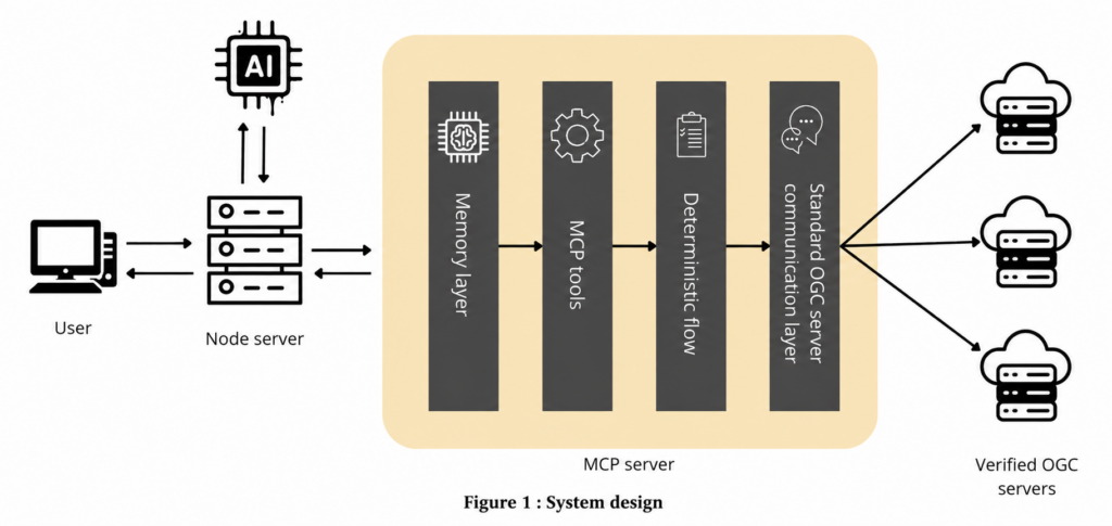 This separation turned out to be important. The language model is useful for understanding a user’s request and selecting the next action, but it should not be responsible for executing arbitrary HTTP requests, approving a process on the user’s behalf, or deciding whether raw geospatial data is safe to render.
How a User Request Travels Through the System
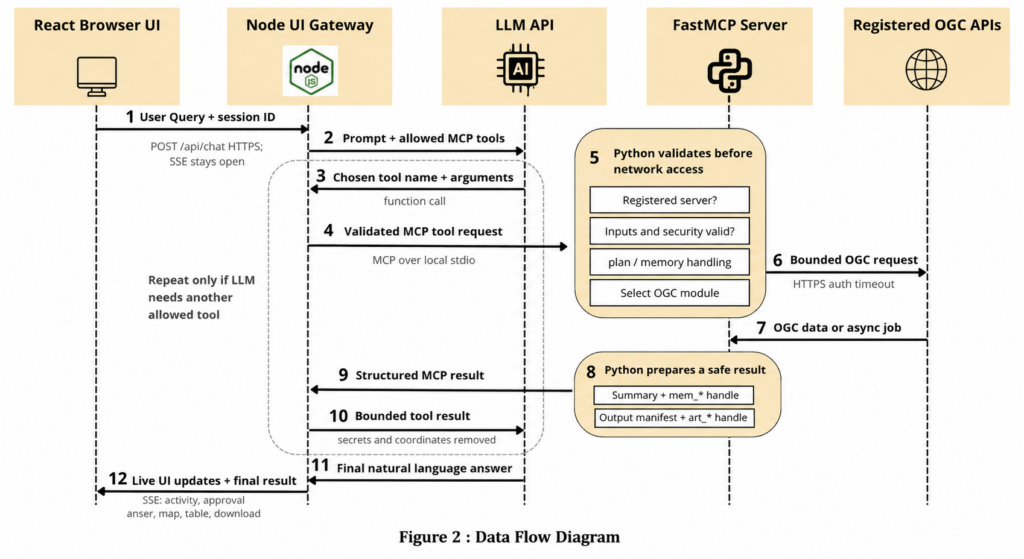
A normal interaction starts in the React chat interface. The user can ask a question such as “Show wildfire risk near Seattle.” React sends the message to the Node.js gateway. The gateway opens a streamed response so that the user can see progress while the request is being handled. It loads the MCP tools that Gemini is allowed to use and sends Gemini the conversation plus the available tool schemas. Gemini can then either write a response immediately or request a tool call. For a geospatial request, it will usually begin with discovery. It may list the configured OGC servers, inspect a landing page or conformance information, search records, inspect a feature collection, list processes, or describe a specific process.
When Gemini requests a tool, the Node gateway calls that tool on the Python MCP server. The Python server then communicates only with OGC API deployments that have been registered by the operator. It returns a structured result to Node. Node prepares a safe version of that result for Gemini, sends it back into the conversation, and asks Gemini whether another tool call is needed. This creates a controlled tool loop:
user request
- React UI
- Node gateway
- Gemini chooses a tool
- Node calls Python MCP tool
- Python calls a registered OGC API
- structured result returns to Node
- Gemini either chooses another tool or writes the final answer
- React shows the answer and any prepared visual output
The gateway limits this loop to a bounded number of rounds. This prevents an uncontrolled sequence of tool calls while still allowing multi-step workflows, such as discovering a dataset before choosing a process to run.
Safe Process Execution With Human Confirmation
One of the most important parts of the project is the process-execution workflow. OGC API – Processes operations can trigger real geospatial computation, potentially using large inputs or long-running jobs. A model should not send a guessed execution request directly to a server. The workflow therefore follows these stages:
discover process
-> describe its exact schema
-> create a plan
-> resolve missing or ambiguous inputs
-> show the exact request to the user
-> record the user’s decision
-> execute the confirmed plan
The model starts by calling ogc_processes_list and ogc_processes_describe. This gives it the exact process identifier, input names, input types, and output information advertised by the OGC API server. It then calls ogc_proxy_create_plan with the proposed execution request.
The Python planner validates the plan against the process description. It checks required inputs, basic input types, source references, process and collection identifiers, and material assumptions such as units, coordinate reference systems, coordinate order, or values that were inferred rather than explicitly given by the user. If something is missing, the plan enters needs_resolution. The interface can ask the user one specific question and update the same plan once the answer is available. If the request is valid, the plan becomes ready_for_confirmation.
At this stage, the React UI displays the exact execute_request in an approval card. The Node gateway creates a fingerprint of the plan, its selected server, the execution request, the input context, and the planned steps. When the user clicks Approve or Reject, the browser sends that decision directly to Node. It does not pass through Gemini.
Before recording approval, Node fetches the current plan again and compares its fingerprint with the version that was shown to the user. If the plan changed, the user has to review it again. If it is identical, Node records the decision through ogc_proxy_confirm_plan. Only then can ogc_proxy_execute_plan run the stored request using its plan_id. This makes the workflow auditable and avoids treating a general natural-language request as approval for a final, detailed process payload.
Handling Large Geospatial Responses Carefully
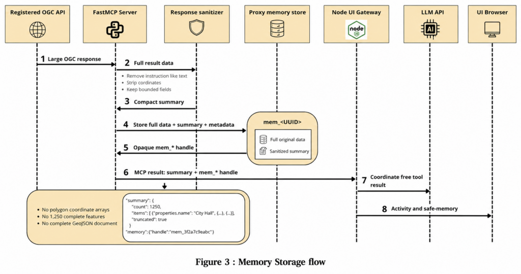
Geospatial responses can be very large. A FeatureCollection may contain many features and coordinate arrays; a process output can contain geometries, files, tables, or references to additional results. Sending all of this into an LLM context would be expensive, hard to reason over, and unsafe. To address this, I continued the proxy-memory approach introduced at midterm. Tools that can return large or unbounded responses use summary mode by default. The Python server stores the complete response behind an opaque mem_* handle and returns only a compact, sanitized summary to the MCP client.
For a feature collection, that summary can include the number of features, feature IDs, geometry types, and selected property values. It deliberately does not include full coordinate arrays. The original data remains available behind the memory handle and can be retrieved in bounded pages when it is genuinely needed.
The Node gateway adds a second protection layer before giving a result to Gemini. It strips coordinates, geometries, bounds, latitude/longitude fields, secret-like values, and overly deep or large structures. Gemini receives useful identifiers, scalar facts, warnings, and result status, but it does not receive the raw spatial payload needed to render a map. This means that the model can answer questions such as “How many features were returned?” or “Which process output is available?” without becoming a place where the system tries to perform geospatial computation on a huge coordinate array.
From Proxy Memory to a Map
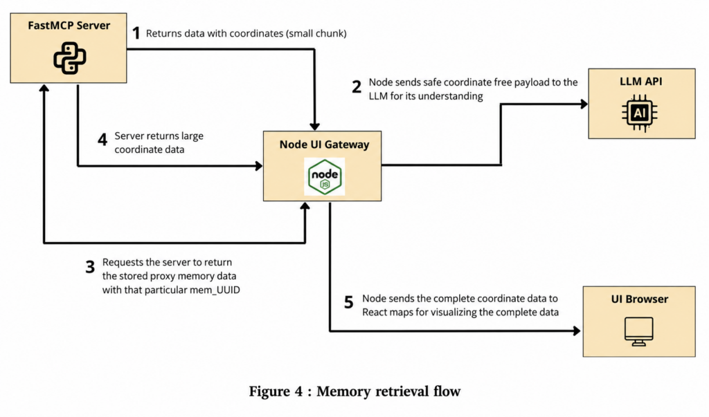
Keeping coordinates out of Gemini’s context does not mean that the user loses the ability to see a map. The rendering path is separate from the reasoning path. When Node needs to prepare a visualization, it can privately retrieve a bounded slice of the stored mem_* payload. This retrieval happens outside the model conversation. Node validates the geometry, coordinate ranges, coordinate reference system, bounds, and size limits, then produces a browser-safe map visualization. That visualization is streamed directly to React. React renders the visualization with MapLibre GL. Supported feature outputs can be shown as points, lines, polygons, multi-geometries, or geometry collections. Dense point collections can be represented as heatmaps. The map renderer also shows layer information, feature properties, warnings, and truncation details. The system fails when the data cannot be mapped safely. For example, unknown coordinate reference systems, missing coordinate semantics, invalid coordinate ranges, or ambiguous x/y columns do not become a misleading map. Instead, the user receives a table, a download, or a clarification request.
Process Output Artifacts and Visual Presentations
The second major addition in the final phase was a full output-artifact pipeline. Process execution and output presentation are not the same thing. A process can report success while its output is still being published, stored behind a reference, encoded in an unsupported format, or unavailable for a browser preview. The Python server therefore creates an output_manifest for process outputs. For every output, the manifest separately records:
- the execution state;
- whether the output was retrieved;
- whether its format and semantics were understood;
- which presentations are ready for the user interface;
- provenance, warnings, and clarification requirements.
The artifact pipeline preserves the original output behind an opaque art_* handle. When possible, it also creates a canonical representation and a bounded preview representation. For example, an upstream vector result can be normalized into GeoJSON for a map preview while the full original file remains available for download. This allows the UI to choose the right presentation based on the actual output rather than guessing from the user’s original question.
UI presentation
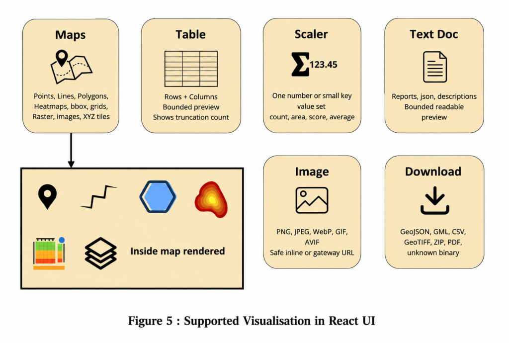 The React OutputPanel uses a renderer registry to select components for maps, tables, charts, metrics, images, text, and downloads. Importantly, the system does not tell the UI that a map is ready merely because a process succeeded. A map appears only after a valid drawable layer has been prepared.
Supporting Asynchronous Jobs
Some OGC API processes return immediately with an asynchronous job instead of a final result. The interface now supports this workflow as well. When a confirmed process returns a trackable asynchronous response, Node stores the job and server identifiers and polls its status in the background. The original chat response can finish while the job continues. Once the job is successful, the gateway retrieves the result, passes it through the same artifact pipeline, and updates the original conversation with progress and a prepared map when a supported spatial result is available. The system also handles the realistic case in which a job reports success before its result endpoint is ready. It uses bounded retries for temporary result-publication states and reports an explicit unavailable state rather than leaving the interface permanently loading.
What I Delivered
Over the course of the project, I delivered the following main pieces of work
- an experimental OGC API-to-MCP mapping and tool contract;
- a standardized Python FastMCP reference server for Common, Features, Records, Processes, and Jobs workflows;
- an operator-owned registry so tools use configured OGC API servers rather than arbitrary user-provided URLs;
- discovery-first tools for OGC API capabilities, collections, records, and processes;
- a deterministic, human-confirmed plan workflow for OGC API – Processes;
- proxy memory and coordinate-free summaries for large responses;
- in-memory option for plans, memory, and artifacts;
- a React chat interface and a Node.js Gemini gateway;
- safe streamed tool activity, approval cards, and background-job updates;
- process-output manifests, artifact storage, renderer preparation, and secure artifact downloads;
- interactive map, table, chart, metric, image, text, and download presentations;
- unit tests and documentation covering the tool contract, security boundaries, plan lifecycle, memory, artifacts, configuration, deployment, and extension.
Reflections
The biggest lesson from this project is that connecting a language model to an API is not mainly a matter of exposing endpoints. The difficult part is designing the workflow around the endpoint. For OGC APIs, that means helping the model discover the right server and capability, preserving exact process schemas, preventing it from guessing coordinate semantics, keeping large results outside its context, requiring a human decision for consequential actions, and being honest about what was actually retrieved, interpreted, and rendered.
I also learned that visual output needs its own safety model. A successful process does not automatically justify a map. A browser should not load an arbitrary output URL, and a map should not appear when the CRS is unknown or a coordinate array is ambiguous. The output manifest and renderer registry made those decisions explicit instead of hiding them in application code.
My work moved the project from a backend bridge toward a usable research prototype. A user can now focus on a geospatial question, while the system guides the model through discovery, validation, execution, result handling, and presentation.
Closing
I am grateful to 52°North, my mentors Benjamin Proß, and the Google Summer of Code program for this opportunity. This project gave me a much deeper understanding of geospatial web APIs, MCP tool design, security boundaries, user-centered workflow design, and the practical challenges of building AI-assisted systems that remain transparent and controllable. I am excited to continue improving this work and to explore how a structured MCP layer can make powerful OGC API capabilities more accessible to a wider range of users.
LinkedIn: https://www.linkedin.com/in/pranav-angrish
GitHub repository: https://github.com/PranavAngrish/OGC-MCP-Service
Rechecking the plan fingerprint before recording approval is a thoughtful safeguard—it ties consent to the exact payload the user reviewed, not just their original request. The bounded retries for jobs that finish before their results are available also address an easy-to-miss failure mode. Does the interface highlight what changed when a plan needs a second review?