 Empowering Conservation Through Open Technologies with 52°North and PEOPLE-ECCO
The Challenge
Non-Governmental Organizations (NGOs) are key actors in the conservation and restoration of ecosystems worldwide. However, practice-oriented conservation groups face a major hurdle: evaluating the real-world impact of their management activities over large geographic areas. Traditional monitoring methods rely on labor-intensive on-the-ground surveys, which are difficult to sustain at scale. While satellite Earth Observation (EO) data, such as Copernicus Sentinel-2, offer wide-scale coverage and long-term time series, using them effectively requires complex domain knowledge, spatial data handling, and specialized data processing skills.
This week’s challenge is:
How can we build an accessible, cloud-native web platform that transforms complex satellite Earth Observation data into intuitive environmental indicators and actionable metrics for non-technical conservation experts?
The Stakeholders and Co-Design
To bridge the gap between space infrastructure and ground-level species conservation, the European Space Agency (ESA) funded the PEOPLE-ECCO (Enhancing Ecosystems Conservation through Earth Observation Solutions, Capacity Development and Co-design) project under its EO4Society program. Led by the University of Twente (ITC), the consortium brings together technical and domain partners – 52°North, Hatfield Consultants, and DHI Consulting – alongside six key NGO “Early Adopters” across four continents:
- African Parks: Monitoring protected areas across multiple African nations.
- Bulgarian Society for the Protection of Birds (BSPB): Preserving critical bird habitats and grassland ecosystems in Bulgaria.
- IUCN Vietnam: Protecting forest and wetland ecosystems.
- Lebanon Reforestation Initiative: Restoring forested landscapes and building community resilience in Lebanon.
- Prince Edward Island Watershed Alliance (Canada): Tracking watershed health and cold-temperate aquatic ecosystems.
- Reef Check Malaysia: Conserving high-biodiversity coral reefs, seagrass beds, and coastal marine habitats.
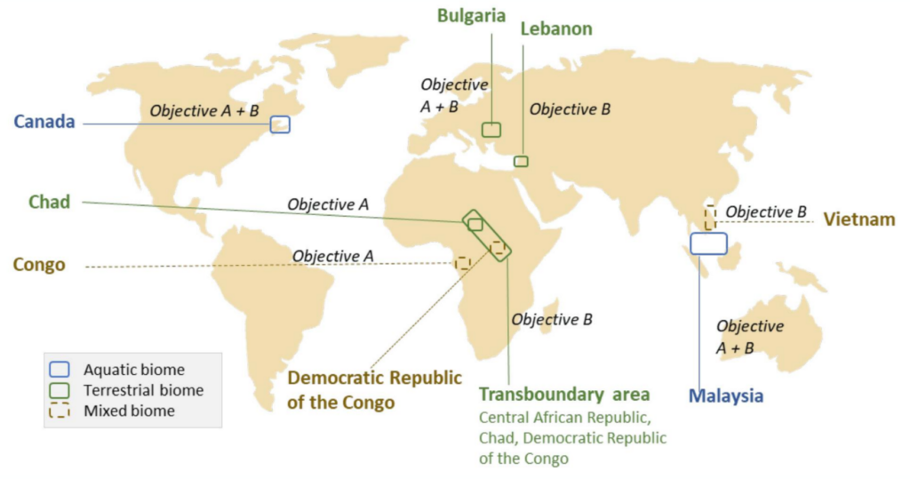
Through hands-on Living Labs (such as at BioSpace25 conference) and targeted regional co-design workshops (e.g., in Kuala Lumpur and Plovdiv), these non-technical stakeholders worked directly alongside the technical developers to co-design the system requirements, refine workflows, and shape the user interfaces.
The Technical Architecture
As the software architecture and platform engineering lead, 52°North designed, implemented and deployed the technical foundation.
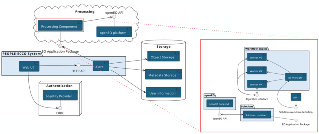
We also developed the open-source PEOPLE-ECCO Platform to address the needs of GIS professionals, domain specialists, and public stakeholders:
- Central API (ecco-api): Designed as a RESTful API, ecco-api serves as the primary backbone of the system. It enforces access permissions, handles OpenID Connect (OIDC) authentication via Keycloak, manages conservation sites configurations (area of interest, applicable algorithms), while handling algorithm execution and result retrieval.
- Hybrid Processing Engine: Heavy satellite processingEO data processing – such as the discovery and retrieval of Sentinel-2 data, cloud masking, band sub-setting, spatial resampling and calculating spectral indices (e.g., NDVI, SAVI, NBR) – is offloaded directly to the openEO Platform within the Copernicus Data Space Ecosystem (CDSE). The Prefect workflow engine, Garage S3 storage and PostgreSQL/PostGIS databases enable seamless custom statistical analyses and post-processing. The engine tracks asynchronous batch jobs, automates credentials management for the CDSE using dedicated service accounts (so users do not need to manage these on their own) and provides outputs and results via standardized SpatioTemporal Asset Catalogs (STAC).
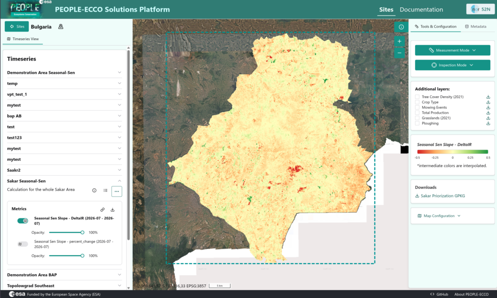
- Web User Interface (ecco-web): Built with the Open Pioneer Trails framework, This browser-based web application enables non-technical users to run pre-defined, parameterizable PEOPLE-ECCO solutions. They can visually explore time series, inspect Cloud Optimized GeoTIFFs, monitor execution progress and download indicator datasets (see figure 3).
- Standardized Integration and FAIR Execution: Custom models from consortium partners are packaged as Docker containers (ecco-algorithm-base) using Common Workflow Language (CWL) and OGC Earth Observation Application Packages (EOAP). Outputs are served via standardized SpatioTemporal Asset Catalogs (STAC), adhering to ESA APEx guidelines for long-term sustainability.
Today’s Take Away
The PEOPLE-ECCO project demonstrates how open source software, cloud-native standards and collaborative co-design can enable the power of satellite data for ecosystem conservation. By combining openEO cloud processing, dockerized CWL workflows and an intuitive web platform, the PEOPLE-ECCO project has provided NGOs with a modern and scalable toolset to support monitoring, restoration and conservation of ecosystems. All platform components, algorithms, and demonstration outputs developed under PEOPLE-ECCO are open-source and freely accessible to the broader community.
Explore, use, and build upon these contributions directly!
- 💻 PEOPLE-ECCO Software Repositories: Access the open-source platform components and containerized algorithm definitions on GitHub: PEOPLE-ECCO.
- 📖 User Handbook: Read the operational guidelines and workflow explanations in the PEOPLE-ECCO User Handbook
- 🌐 Project Results Browser: Inspect actual demonstration site results via the ESA STAC Project Result Repository
- 🎥 Webinar: Watch the data.europa.eu session “From Space to Species”
- 🌍 Official Website: Visit the PEOPLE-ECCO Website for project overviews and updates.
Leave a Reply