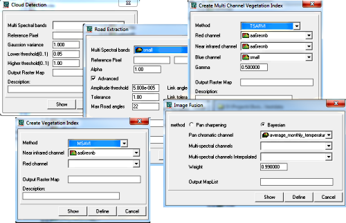
The last weeks I mainly wrote about the next generation of Ilwis. But this is only part of my work, the smaller part even. The main work still goes to Ilwis 3. Undoubtedly there will come a point when the work on Ilwis 3 will only be maintenance but that is still some way off in the future. So what have I been doing in in Ilwis 3? Four main things
- Integrating parts of the Orfeo library into Ilwis
- Integrating WFS import into Ilwis
- Extending the ILWIS WPS
- Debugging
The main part of my work has been the integration of the Orfeo library into Ilwis. Orfeo is a big remote sensing library of CNES (http://www.orfeo-toolbox.org/otb/) that I wanted to be available in ILWIS for some time. Not that I need or want everything from that library but there are still a lot of routines in there that are useful to have available in Ilwis. The planning at the moment is that the following becomes available in the Ilwis 3.8.4
- Vegegation indexes (~10 routines)
- Atmospheric correction
- Image fusion
- Cloud detecttion
- Road extraction
- Image segmentation
- Some unsupervised classification schemes
- Unmixing
We will see if we can achieve this. At the moment (27-5-2013) I have done : vegetation indexes, image fusion, cloud detection and road extraction.
It was a bit of work to properly built the orfeo library and integrate it in Ilwis but that seems to work ok at the moment. It is still quite a lot work to make an operation available in Ilwis even if I don’t have to write the algorithm(s) myself. Orfeo and Ilwis use quite different models and data types and they all have to be converted and back again (and there is of course the UI).
For a number of operations Orfeo requires a reference spectrum to be used. That is a cross section of a multi spectrum data set that can be used as base line for a particular physical phenomenon. There are two ways of achieving it in Ilwis 3.8.4.
- First of all the context menu of the map window has been extended with an option “copy coordinate”. This puts the current clicked coordinate on the map, on the clipboard and this can be pasted into every coordinate field in the UI ( sigh, why this didnt exist before in Ilwis I don’t know, it is so useful at many other places in the software). The location can be used as reference point from where the spectrum is taken to be used. It is somewhat crude as you can’t see the spectrum to see if you have the correct point but it usually get the job done
- A more precise way is to use a (new) spectrum file. You can do this by using the cross section tool with an appropriate data set, pick one or more points at the map and save the result to the spectrum file. The points will be merged (different options there) and the result can be used in operations that need a reference spectrum. This is much more precise than first method but a little bit more work.
Orfeo is for me an example of one of the (main) roles I see for Ilwis in the future even if this is built in the Ilwis3 line. There is lots of perfectly fine free open source functionality available with mediocre or bad accessibility for non expert users. I don’t have to write all the algorithms myself; other have more time and expertise to do that. I do know however that Ilwis has always been able to provide a consistent and fairly easy to use user interface. If I am able to use that expertise together with a consistent integration model (connectors) than we have a win-win situation. Ilwis wins (functionality) and the makers of the libraries win ( enlarged user based).
Next week I will write about the deep internals of the raster model and its consequences for Ilwis-Objects.

Hello there,
Is there any tution about atmospheric correction in ilwis?