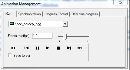
One of the specific purposes of 3.8 was the improvement of the animations in ILWIS. These days there is so much spatial temportal data available and the amount of research directed at that is staggering. There are many ways to study spatial temporal data but one of the important ones is by animations.
ILWIS had a fairly primitive animations facility but that was not sufficient for the level of visual analysis I deemed necessary for ILWIS 3.8. Fortunately, here the ITC, there was some years ago, in the context of the reasearch work of C. Block (http://www.itc.nl/personal/blok/), a prototype made by W. Nieuwenhuis of a tool called ANIMVIS. It displayed a lot of the properties I felt were necessary for an animation tool for visual analysis. I used these ideas as a basis for the work on animations.
So what were my goals? Well
- In all respects,were it made sense, it should work as a normal layer in the mapwindow. Meaning that an animations is just a layer and all the display properties that I can change for a “normal” layer should also work for the animation. E.g. Dynamic stretching works for a normal layer, so it should also work for the animation
- Animations of both raster en vector maps should be possible. The basic datastructure for raster is the maplist and for vector layers the object collection.
- The user must have full control of the dynamics of the animation ( start, stop, pause, frame by frame, speed etc…).
- Synchronization between different animations must be possible. Both on index basis as on “real time” basis (if available).

Leave a Reply