I would like to introduce the project “Using the ILWIS framework for geo-data capture with a mobile application”. This is one of the Google Summer of Code projects hosted by 52°North.
The project is mentored by ITC since they are the developers of ILWIS-Objects. ILWIS-Objects is the next generation ILWIS, which is a GIS environment. The idea behind it is that it won’t be ‘just’ a desktop GIS application, but a framework for many different scenarios, applications and platforms.
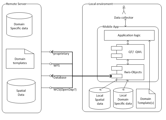
The ILWIS framework will now be extended to a mobile app. This app will enable someone who is collecting data in the field to store his/her data on a remote server. This will include domain data but, of course, also spatial data about the point of observation. In addition, it will be possible to retrieve and visualize domain specific spatial background data, such as basemaps, historic measurements or administrative maps. This will be a key element of the app. By using the ILWIS-Objects framework for handling the spatial data, the app will contain a powerful spatial component.
Flexibility is furthermore a key aspect of the app, for example, flexibility in the location where it is used. This means it should work without internet connection, so it should be possible to store not only background data locally, but also the measurements until the mobile phone is at a place with internet connection again. Flexibility in domain of use will also be important: from collecting data about maintenance of water pumps, or data about animals, to assessment of health risks. This goal will be met by implementing templates for different functions. It will be possible for a user to make his/her own data collection template, which can be loaded into the app from a remote server.
Summarizing, the app will look like this:

About me
I’m Bouke Pieter Ottow, born in Indonesia, grown up and living in the Netherlands and a cosmopolitan. I have a bachelor in Civil Engineering (at the University of Twente) and I’m mastering Geo-Information Science at the University of Wageningen. Applying high tech (geo-information) science in developing countries makes me enthusiastic.
I will work on this project the coming three months, but at full speed mainly in July and August. Questions, comments, critics, compliments or just expressions of interest are more than welcome (as comments on this post or emailed to )!
Congratulations with your plan to get ILWIS on mobile platforms.
It will be great to be able to enter data and location coordinates directly.
And to do observations via a smartphone or tablet that you have with you while on the urban street or in the field.
I wish you a lot of succes and I hope to receive good news about the advancement of your project.
Jan Hendrikse. Ex-ILWIS developer , mainly working with spatial data, containing 2D- and 3D-coordinates.
I am joining the congratulations. Let’s develope ILWIS!