There are only two hard things in Computer Science: cache invalidation and naming things.
Phil Karlton
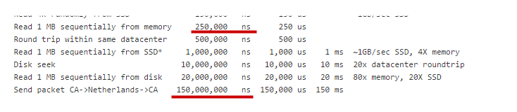
Caching is a common technique to improve the response time of a data source. A cache is a temporary storage for a most often acquired data. Caching is widely used in a proxying software such as Squid. The caching of network responses can provide a huge improvement to the response time. The latency of a network resource is much more greater than of a memory or a disk resource [Fig.1]. That’s why the caching is a “must-have” feature of network proxies.